


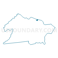
Union township voting district 18, Union County, New Jersey
About
Outline

Summary
| Unique Area Identifier | 622683 |
| Name | Union township voting district 18 |
| County | Union County |
| State | New Jersey |
| Area (square miles) | 0.14 |
| Land Area (square miles) | 0.14 |
| Water Area (square miles) | 0.00 |
| % of Land Area | 100.00 |
| % of Water Area | 0.00 |
| Latitude of the Internal Point | 40.70861740 |
| Longtitude of the Internal Point | -74.24994000 |
Maps

Graphs
Select a template below for downloading or customizing gragh for Union township voting district 18, Union County, New Jersey


Neighbors
Neighoring Voting District (by Name) Neighboring Voting District on the Map
- Hillside township ward 1 voting district 1, Union County, NJ
- Irvington township ward West voting district 10, Essex County, NJ
- Irvington township ward West voting district 9, Essex County, NJ
- Union township voting district 27, Union County, NJ
- Union township voting district 28, Union County, NJ
- Union township voting district 40, Union County, NJ
Top 10 Neighboring County Subdivision (by Population) Neighboring County Subdivision on the Map
- Union township, Union County, NJ (56,642)
- Irvington township, Essex County, NJ (53,926)
- Hillside township, Union County, NJ (21,404)
Top 10 Neighboring Unified School District (by Population) Neighboring Unified School District on the Map
- Union Township School District, NJ (56,642)
- Irvington Township School District, NJ (53,926)
- Hillside Township School District, NJ (21,404)
Top 10 Neighboring State Legislative District Lower Chamber (by Population) Neighboring State Legislative District Lower Chamber on the Map
- General Assembly District 28, NJ (210,635)
- General Assembly District 20, NJ (210,628)
- General Assembly District 29, NJ (206,523)
Top 10 Neighboring State Legislative District Upper Chamber (by Population) Neighboring State Legislative District Upper Chamber on the Map
- State Senate District 28, NJ (210,635)
- State Senate District 20, NJ (210,628)
- State Senate District 29, NJ (206,523)
Top 10 Neighboring 111th Congressional District (by Population) Neighboring 111th Congressional District on the Map
Top 10 Neighboring Census Tract (by Population) Neighboring Census Tract on the Map
- Census Tract 324, Union County, NJ (7,531)
- Census Tract 120, Essex County, NJ (5,812)
- Census Tract 326, Union County, NJ (5,129)
- Census Tract 323, Union County, NJ (2,265)